An Inter-Institutional Platform
for PhDs, PostDocs and ECRs in
Architectural History and Theory,
Landscape and the City
for PhDs, PostDocs and ECRs in
Architectural History and Theory,
Landscape and the City
︎
Regular Talks
︎︎︎Online Sessions Link︎︎︎
︎
︎︎︎Online Sessions Link︎︎︎
Forthcoming - TBA
10:00 AM EST / 4:00 PM CET
What’s Wrong with the Rural House?
On Realism and Myth in Giuseppe Pagano’s Photography
JOLANDA DEVALLE
École Polytechnique Fédérale de Lausanne (EPFL)
Respondent: Mireille Roddier, University of Michigan
![]()
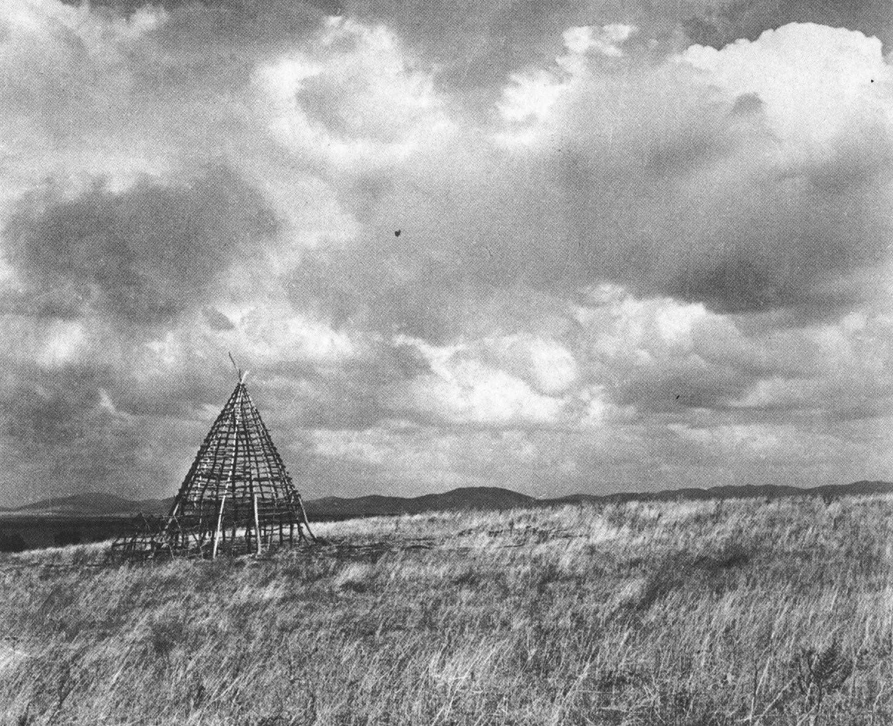
Giuseppe Pagano, Haystack in the Roman Agro, 1935.
***
The Architecture of the Making of the Author
SEVGİ TÜRKKAN
Istanbul Technical University
Respondent: Mireille Roddier, University of Michigan
![]()
The architecture of the making of the author: Tracing the pedagogy of the "loge" in the Ecole des Beaux-Arts tradition.
10:00 AM EST / 4:00 PM CET
What’s Wrong with the Rural House?
On Realism and Myth in Giuseppe Pagano’s Photography
JOLANDA DEVALLE
École Polytechnique Fédérale de Lausanne (EPFL)
Respondent: Mireille Roddier, University of Michigan
Giuseppe Pagano, Haystack in the Roman Agro, 1935.
This paper reconsiders Giuseppe Pagano’s Exhibition on Rural Architecture, presented at the VI Milan Triennale in 1936, a project built around an unprecedented photographic campaign of rural dwelling across Italy, much of it shot by Pagano himself. In architectural historiography, the exhibition has long been hailed as an “anthropological inquiry,” a paradigm shift away from stylistic canons and capital-A Architecture toward humble and overlooked every-day environments. After 1945, this reading became closely bound to Pagano’s own tragic trajectory—his break from fascism in 1943, participation in the Resistance, and his death in Mauthausen in 1945. Through a redemptive lens, postwar leftist scholarship interpreted the rural exhibition as a profoundly ethical endeavor: a realist search for architecture’s collective foundations, an antidote to fascist rhetoric, an early precursor to Neorealist sensibilities. Interpretations which collectively elevated Pagano and his work as figures of critical resistance, a narrative this paper seeks to revisit and complicate.
In light of today’s renewed yearnings for the so-called vernacular and rural imaginaries, this paper approaches Pagano’s exhibition through a different and seldom discussed lens: his 1939 photographic sequence and photobook Il Covo, depicting Mussolini’s editorial office—“the lair”—the mythologized birthplace of fascism. Viewed alongside Il Covo, Pagano’s celebrated “anthropological” inquiry reveals a more ambivalent aesthetic: a double movement in which realism and myth operate simultaneously. Through a close reading of photographs, his writings in Casabella, and the catalogue Architettura rurale italiana, the paper argues that Pagano’s mode of realism isolated and abstracted fragments of the real—neutralizing class conflicts and contingency—to produce archetypal, almost mythical forms and gestures. This reframing complicates his status as precursor to postwar Neorealism and situates Pagano’s visual practice within recent philosophical reflections on fascism’s capacity to transform “reality” through myth.
In light of today’s renewed yearnings for the so-called vernacular and rural imaginaries, this paper approaches Pagano’s exhibition through a different and seldom discussed lens: his 1939 photographic sequence and photobook Il Covo, depicting Mussolini’s editorial office—“the lair”—the mythologized birthplace of fascism. Viewed alongside Il Covo, Pagano’s celebrated “anthropological” inquiry reveals a more ambivalent aesthetic: a double movement in which realism and myth operate simultaneously. Through a close reading of photographs, his writings in Casabella, and the catalogue Architettura rurale italiana, the paper argues that Pagano’s mode of realism isolated and abstracted fragments of the real—neutralizing class conflicts and contingency—to produce archetypal, almost mythical forms and gestures. This reframing complicates his status as precursor to postwar Neorealism and situates Pagano’s visual practice within recent philosophical reflections on fascism’s capacity to transform “reality” through myth.
***
The Architecture of the Making of the Author
SEVGİ TÜRKKAN
Istanbul Technical University
Respondent: Mireille Roddier, University of Michigan

The architecture of the making of the author: Tracing the pedagogy of the "loge" in the Ecole des Beaux-Arts tradition.
The late 20th century saw the intensification of attempts that expose the author as a theoretical, traditional and disciplinary construct in its complex socio-cultural entanglements. This Post-doctoral research, additionally, aims to take on a spatial perspective in the construction of the author-figure, focusing on one of the most formative chapters in the history of architectural education with continuing reverberations today.
When the seminal École des Beaux-Arts was re-established in its new complex on Rue Bonaparte in 1820, “Bâtiments des Loges” (The-Loges-Building) was the first building to be completed and used in 1824. “Loges” can be described as individual cubicles aligned on a corridor, divided by rigid walls, strictly regulated and kept under probation by guardians in order to isolate students physically and socially from the outside world and each other during the periods of architectural competitions (ranging from 2 hours to 3 months), including the prestigious Prix de Rome. Inherited from Academie Royal D’Architecture, loges were central to the pedagogy and curriculum of the École (Levine, Middleton, 1984). To counter the anonymity in the ateliers, loges assured competitors an uninterrupted space, allowing them to manifest their personal skills with a guarantee of claiming the credits in person. Although lesser published, and was abandoned after the École’s dissemination in 1968, this tiny spatio-pedagogic unit has been profound in maintaining the École des Beaux-Arts system and culture, which served as the prevalent model for institutionalized architectural education 19th century onwards.
A brief account of this lasting spatio-pedagogic tradition attempts to pin down the often-mystified production of the author in spatial lieu, revealing the socio-spatial mechanisms enabled and triggered by its architecture: the conception of creativity and isolation, the rituals of competition and surveillance, the stories of accomplishments and misbehavior.
Through a selection of drawings, postcards, administrative documents and letters from 19th and 20th century archive materials, the study will display and discuss a brief account of the “loges” as a pedagogic instrument, a cultural incubator and an authorship inscribing mechanism.